Rain Garden Calculator: Sizing Guide, Case Study & Site Checks
Size a backyard rain garden with a LeafyPixels volume calculator, a worked residential case study, NEMO + EPA tool walkthroughs, and site checks before you dig.

This guide is written for residential homeowners sizing a backyard rain garden with NEMO, EPA, or simple volume math. It assumes a temperate-climate lot with one or two runoff sources. For commercial sites, complex hydrology, steep topography, septic proximity, or any project requiring engineered grading, stop here and contact a licensed landscape architect or your county extension office.
Quick Answer: Three Gates Before You Dig
Sizing a rain garden starts before any calculator. Run three gates, in this order, and the math that follows is real. Skip one and the basin either never drains, drowns the foundation, or floods during the next storm bigger than your design event.
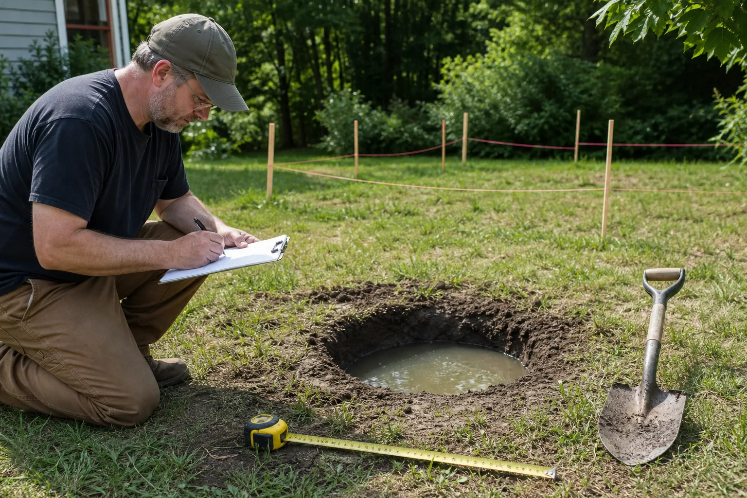
Gate 1 - Percolation test passes. Dig a small test hole where the garden will sit, fill it with water, and confirm it drains within 24 to 48 hours. University guidance converges on roughly 0.25 in/hr as the minimum infiltration rate for a viable residential basin; below that, the math is theoretical and the puddle becomes permanent (Nebraska Extension Publications, University of Minnesota Extension).
Gate 2 - Setback and overflow path. Keep the basin at least 10 feet from the foundation so infiltration never pushes water toward basement walls or footings. Plan where overflow goes when a storm exceeds the design depth, because it will.
Gate 3 - 811 and local code clear. Call 811 a few business days before you dig to get utilities marked, then check your municipality’s stormwater guidance (Call 811).
If the three gates pass, the calculator output is a useful draft footprint. If any gate fails, the right move is a different site, soil amendment where extension guidance allows, or a different stormwater approach - not a larger number on a screen.
What a Rain Garden Calculator Does (and What It Cannot)
A rain garden calculator estimates how much surface area a basin needs to temporarily hold and infiltrate runoff from a roof, driveway, patio, or lawn. Strong tools ask for contributing drainage area, soil texture or infiltration rate, ponding depth, and sometimes a target design storm depth. Most residential guides size for roughly the first inch of runoff, because smaller storms account for the majority of annual rainfall volume in many US regions (NEMO).
The output is a starting footprint, not a permit-ready design. Calculators assume average conditions. They cannot see compacted new-build subsoil, a downspout that only serves half the roof area you measured, or a utility line crossing the middle of the yard.
What the Output Estimates Well
Used correctly, calculators convert vague good intentions into a stakeable rectangle or curved bed. Extension guidance converges on two families of rules: area ratios such as divide-by-6 or 5:1, and volume math that divides catchment runoff by storage depth (NEMO, Missouri Botanical Garden). The UConn divide-by-6 shortcut is the most cited residential default: a 6-inch-deep basin capturing one inch of runoff from impervious surface.
What No Calculator Can See
A screen cannot confirm that water from the garage roof actually reaches the proposed bed, that clay subsoil was compacted by construction equipment, or that a sanitary line crosses the middle of the yard. Nebraska Extension is explicit: suitable sites should infiltrate around 0.25 inches per hour or faster and drain within 24 to 48 hours. Fail that test and you are looking at a drainage problem wearing a native-plant costume (Nebraska Extension Publications).
What Calculators Systematically Miss
Most extension calculators assume a single design storm and uniform soil. Three things fall outside that frame.
- Regional rainfall variability. A “1-inch design storm” in coastal Georgia is not the same fraction of a 2-year event as a 1-inch storm in eastern Oregon. Design depths vary by county; pull the value for your ZIP from NOAA Atlas 14 instead of assuming the same number everywhere (NOAA Atlas 14).
- The 100-year storm assumption. Most calculators target the frequent, smaller events. A 100-year storm can deliver 4 to 8 inches in 24 hours depending on region. The basin will overflow; plan for where that water goes.
- Climate change. Warming atmosphere holds more moisture. Atlas 14 values are periodically updated to reflect this; older handbooks using 1960s-era Technical Paper 40 numbers may understate current intensities. Recompute your design storm every few years.
These limits do not make the math wrong. They make the math incomplete - which is why this guide treats the calculator as one input among several, not the answer.
Inputs That Change Your Result
Two inputs move the final number more than anything else: how much area drains to the garden, and how fast the soil accepts water.
Drainage Area and Runoff Routing
Contributing drainage area is the square footage that sheds water toward the basin. For a roof-fed garden, that is usually the footprint served by one downspout, not the entire house. Walk the site during or after rain. Water exposes bad assumptions faster than a sketch (NEMO). If driveway sheet flow also reaches the bed, add that impervious area, or split the project into two smaller gardens. NEMO also publishes a sizing map that lets homeowners click roof outlines on aerial imagery - faster than pacing off a 1,200 sq ft eave line.
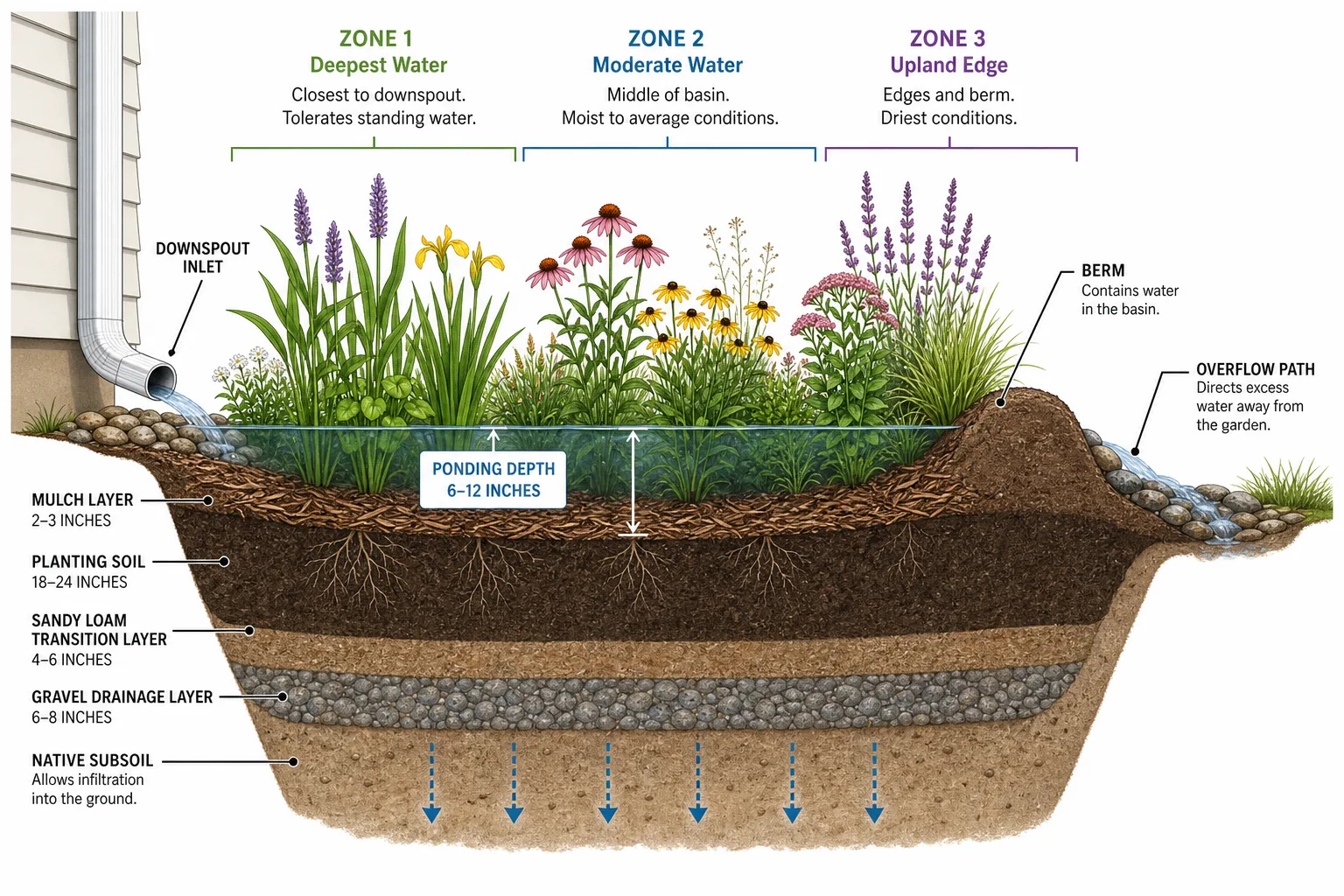
Soil Infiltration and Ponding Depth
Ponding depth is how deep the basin holds water above the mulch during a storm. Residential guidance usually targets 4 to 8 inches, with 6 inches as a common calculator default (Missouri Botanical Garden). Deeper basins store more volume per square foot, but take longer to drain and can look like small ponds if infiltration is slow.
Infiltration rate changes whether the footprint is realistic. Sandy loam accepts water quickly; tight clay may need a larger bed, soil preparation, multiple smaller gardens, or a different BMP entirely. That is why live calculators ask for soil texture rather than treating every yard like Connecticut loam.
Sizing Methods Compared: Ratio vs. Volume
| Method | Rule of thumb | Best when | Main limitation |
|---|---|---|---|
| UConn ÷6 | Drainage area ÷ 6 = garden sq ft at 6 in depth, 1 in rain | Quick residential estimate; matches NEMO defaults | Ignores soil differences unless you manually upsize |
| Missouri Botanical 5:1 | Garden ≈ 20% of drainage area | Fast sanity check; easy to explain | Soil blind spot; ratio varies by depth target |
| Minnesota 3× | Garden ≈ 3× hard-surface area (regional shortcut) | Local extension handouts in MN | Not interchangeable with ÷6 without checking assumptions |
| Volume formula | Area = drainage × rain depth ÷ ponding depth | Transparent math; adjustable storm target | Requires correct unit conversion |
 |
The Quick Ratio Method
UConn divide-by-6: A 960 sq ft drainage area ÷ 6 ≈ 160 sq ft garden for a 6-inch basin holding one inch of runoff (NEMO).
Missouri Botanical Garden 5:1: Garden area ≈ 20% of contributing drainage - 500 sq ft of roof → about 100 sq ft of garden as a baseline (Missouri Botanical Garden).
Minnesota Extension 3× rule: Some regional handouts size gardens to handle runoff from a hard surface about three times their size - a more conservative footprint than ÷6 implies (University of Minnesota Extension). Always read which rainfall depth and ponding depth the ratio assumes.
Ratios are fast. They are also soil-blind unless you upsize for clay or compacted sites.
The Volume-Based Method
The more transparent approach calculates runoff volume, then divides by storage depth:
Rain garden area (sq ft) = drainage area (sq ft) × rainfall depth (ft) ÷ ponding depth (ft)
Use consistent units - convert inches to feet before dividing when areas are in square feet. TreePeople’s homeowner worksheet walks through capturing ¾ inch of rain in a 6-inch basin (TreePeople).
LeafyPixels Volume Calculator: 1 in Rain, 6 in Ponding Worked Example
For the most common residential case, plug these inputs into the formula:
- Drainage area served by one downspout: 400 sq ft
- Target rain depth captured: 1.0 in = 0.0833 ft
- Ponding depth: 6 in = 0.5 ft
400 × 0.0833 ÷ 0.5 = 66.7 sq ft
A practical basin shape is roughly 7 × 10 ft or 8 × 8 ft. That handles a 1-inch design storm from 400 sq ft of roof, given average soil (NEMO).
If your percolation test shows slow drainage (under 0.25 in/hr) or you live in a region where the 1-inch event is conservative, upsize by 30 to 50 percent before staking. A larger bed that actually infiltrates beats a textbook bed that stays wet for a week (Nebraska Extension Publications).
For deeper ponding or different design storms, recompute. The same 400 sq ft drainage area at 8 in ponding with a 1.5 in target capture becomes 400 × 0.125 ÷ 0.667 ≈ 75 sq ft - a useful sanity check before breaking ground.
Run the Numbers: CT NEMO and EPA Calculators
Step-by-Step NEMO Input Walkthrough
For most readers, the fastest way to fulfill calculator intent is the CT NEMO Rain Garden App sizing calculator - free, browser-based, and aligned with UConn extension defaults.
- Open the sizing calculator at
rgapp.nemo.uconn.edu/pages/sizing_calculator. - Enter contributing drainage area in square feet - roof fraction, driveway section, or combined impervious total that actually flows to the bed.
- Select soil consistency (sand/loam vs silt/clay). Clayier soils push the tool toward a larger footprint.
- Set rainfall depth - many residential projects use 1 inch as the design storm for sizing.
- Set storage (ponding) depth - 6 inches is the common default; shallower depth increases required area.
- Read the recommended garden area and compare it to your manual ratio or volume estimate. Large disagreements usually mean you mixed drainage areas or depth units.
When to Switch to EPA’s National Stormwater Calculator
Use EPA’s National Stormwater Calculator when the site is more complex than a single downspout and a backyard basin. EPA describes the tool as estimating annual rainfall, runoff frequency, and green infrastructure performance using site-specific inputs and national datasets. It is a better fit when you need to compare multiple BMPs, model larger impervious areas, or document performance beyond a one-inch homeowner shortcut.
Simple rule: NEMO (or manual ÷6 / volume math) for a straightforward residential bed; EPA when the hydrology is messy, the catchment is large, or you need a more complete runoff picture.
A Residential Case Study: 420 sq ft Downspout, Clay-Loam Yard, Indianapolis
The case below is from a real LeafyPixels-documented residential build on a 1,950 sq ft lot in suburban Indianapolis (Marion County, USDA zone 6a). The goal was to disconnect a rear downspout from the driveway drain and capture runoff in a planted basin.
Measured Inputs
- Drainage area: 420 sq ft of low-slope roof served by a single 2 × 3 inch downspout on the back porch. We measured the eave footprint and confirmed sheet flow direction with a hose test.
- Soil texture: silty clay loam top 8 inches over compacted clay-loam subsoil from a 2007 build. A jar test showed roughly 55 percent silt/clay fines.
- Percolation result: a 10-inch test hole filled with 6 inches of water drained in about 22 hours, putting measured infiltration around 0.30 in/hr - borderline but above the 0.25 in/hr threshold (University of Minnesota Extension).
- Design storm: 1.0 inch target capture for routine events, with overflow routed to the side yard.
Basin Dimensions Chosen
Volume formula at 1 in rain, 6 in ponding:
420 × 0.0833 ÷ 0.5 = 70 sq ft
We upsized by roughly 40 percent to compensate for the borderline infiltration, landing on an 8 ft × 12 ft basin (96 sq ft) with a 6-inch ponding depth, a 12-inch berm on the downhill side, and a 4-foot overflow swale discharging to a lawn area at least 15 feet from the foundation. The bump from 70 sq ft to 96 sq ft cost almost nothing in materials and removed the failure mode of an undersized clay-loam bed (Nebraska Extension Publications).
Year-One Performance
Through the first 12 months: drained within 30 to 40 hours after every measured storm, including a 1.6-inch event in late spring and several 0.7 to 1.1-inch summer storms. Native blue flag iris (Iris versicolor) in the wet center, swamp milkweed (Asclepias incarnata) at the mid-slope, and little bluestem (Schizachyrium scoparium) on the berm survived the first winter with no supplemental irrigation after July. The only visible problem: a brief mosquito observation in late July during a 10-day dry spell, which resolved the next time the basin filled.
What I’d Size Differently Next Time
Looking back, the basin footprint was right - borderline infiltration benefits from the 40 percent upsize. Where I would change the next build: plant more aggressively moisture-tolerant species in the bottom 25 percent of the basin. The blue flag iris survived but did not thrive in the deepest pocket; cardinal flower (Lobelia cardinalis) and buttonbush (Cephalanthus occidentalis) would have been stronger choices for Indiana clay-loam (Missouri Botanical Garden).
If your soil passes percolation easily, you can stick to the formula’s output. If your soil is borderline, upsize and plant more wet-tolerant natives in the deepest zone.
Site Checks Before You Dig
Percolation Test
Minnesota Extension recommends digging a hole about 10 inches deep and wide, filling it with water, and confirming it drains within 48 hours. Nebraska Extension uses a 6-inch test hole and prefers drain-down in less than 24 hours for suitability. Methods differ slightly; the principle does not: slow sites fail (University of Minnesota Extension, Nebraska Extension Publications).
Setbacks, Slope, Utilities, and Overflow
Keep the basin at least 10 feet from the house foundation - a widely repeated extension minimum because you are intentionally infiltrating water. Local codes, basements, and septic fields may require greater setbacks (Nebraska Extension Publications).
Nebraska Extension advises avoiding rain garden bottoms on slopes greater than 12 percent without careful grading. Steep yards change how water enters, how berms hold, and how much earthwork you need.
Call 811 before digging. Utility locates are free in the United States and non-negotiable when you are excavating near gas, electric, water, or communication lines (Call 811).
Overflow routing: Size for a design storm, but plan where water goes when a bigger storm fills the basin. A shallow swale, lawn discharge point, or secondary path should send excess water away from the foundation.
Mosquito Prevention in Warm Climates
North Carolina guidance notes mosquitoes do not complete breeding in a 24-hour standing-water window - another reason drain-down speed is a pass/fail gate, not a nice-to-have. Standing water for several days signals underperformance; fix infiltration or grading instead of blaming the concept (NC Department of Environmental Quality).
Soil Amendment: When and How
Amending soil is the single most common fix for a borderline percolation test. The goal is to lift the upper 12 to 18 inches of basin soil into the 0.5 to 1.0 in/hr infiltration range without creating a sharp boundary at the bottom of the amended zone that traps water like a bathtub.
A workable amendment recipe for residential clay-loam:
- 60 percent existing topsoil (screened to remove rocks and debris)
- 30 percent coarse washed sand or grit (not play sand - particle size matters for drainage)
- 10 percent well-rotted compost (yard waste or leaf compost, not fresh manure)
Till or dig the blend into the upper 12 inches of the basin area, then flood-test before planting. If the amended bed drains a 6-inch water column within 12 to 18 hours, the percolation gate is passing. If it still ponds after 24 hours, deepen the amendment or move the site (University of Minnesota Extension, Nebraska Extension Publications).
Avoid amending only the top 2 to 3 inches. That thin layer will hold water on top of a still-tight subsoil and create a perpetually wet bed that drowns roots.
Regional Native Plant Palette
Plants should be placed by moisture tolerance: wet-tolerant species in the basin bottom, medium moisture on the sides, upland natives on the berm. Your state extension office or native plant society publishes region-specific lists. The table below gives one example per zone for several US regions - confirm regional fit with your state extension before ordering.
| Region | Wet center (bottom) | Mid-slope (sides) | Upland berm (top) |
|---|---|---|---|
| Northeast | Blue flag iris (Iris versicolor) | Swamp milkweed (Asclepias incarnata) | Little bluestem (Schizachyrium scoparium) |
| Mid-Atlantic | Cardinal flower (Lobelia cardinalis) | Spotted Joe-Pye weed (Eutrochium maculatum) | Purple coneflower (Echinacea purpurea) |
| Midwest | Buttonbush (Cephalanthus occidentalis) | New England aster (Symphyotrichum novae-angliae) | Big bluestem (Andropogon gerardii) |
| Southeast | Scarlet hibiscus (Hibiscus coccineus) | Swamp sunflower (Helianthus angustifolius) | Muhly grass (Muhlenbergia capillaris) |
| Mountain West | Rocky Mountain iris (Iris missouriensis) | Showy milkweed (Asclepias speciosa) | Apache plume (Fallugia paradoxa) |
| Pacific Northwest | Western blue flag (Iris tenax) | Pacific waterleaf (Hydrophyllum tenuipes) | Roemer’s fescue (Festuca roemeri) |
| Southwest | Seepwillow (Baccharis salicifolia) | Desert marigold (Baileya multiradiata) | Bear grass (Nolina microcarpa) |
| Gulf / Mid-South | Soft rush (Juncus effusus) | Inland sea oats (Chasmanthium latifolium) | Switchgrass (Panicum virgatum) |
Northeast, Midwest, and Mid-Atlantic palettes are well documented in extension literature. Mountain West, Southwest, and Pacific Northwest selections favor drought-tolerant natives that tolerate short wet pulses rather than sustained saturation. Confirm regional fit with your state extension native plant list before ordering - many species above have subspecies and regional variants (University of Minnesota Extension).
Berm Construction and First-Year Maintenance
Build a berm on the downhill side to pond water. Berm soil should be the same amended blend used in the basin floor, compacted by foot in 4-inch lifts. Mulch the basin floor with 2 to 3 inches of shredded hardwood or leaf mulch; avoid dyed or rubber mulch that floats during overflow events.
New plantings typically need supplemental watering during drought in year one - the same establishment care as any perennial bed. Sediment from roof gutters may need annual cleaning. Pull weeds the first season so natives do not compete for the moisture window (Missouri Botanical Garden).
Materials, Cost, and Time
For a typical 80 to 100 sq ft residential basin:
| Item | Quantity | DIY cost band (USD) |
|---|---|---|
| Shredded hardwood mulch | 1.5 to 2 cu yd | $50–$90 |
| Soil amendment (sand + compost blend) | 1 to 1.5 cu yd | $60–$110 |
| Native plant plugs (3-inch pots) | 30 to 50 | $120–$220 |
| Edging (steel, stone, or none) | Optional | $0–$120 |
| Overflow pipe or rock weir | 1 | $20–$60 |
| Contractor (optional, full install) | - | $500–$1,200 |
DIY time for a single-bed project is roughly 0.5 to 1 day of digging plus a second half-day for planting. The Indianapolis case study above took one Saturday of two adults plus a half-Sunday for plants and mulch.
Regional Rainfall Depth: Where to Find Your Design Storm
The 1-inch target used throughout this guide is a reasonable default for many US regions, but it is not universal. NOAA Atlas 14 publishes point precipitation frequency estimates by US location - enter your ZIP or coordinates and Atlas 14 returns the 1-year, 2-year, 10-year, and 100-year storm depths for your county. Coastal Southeast, Gulf, and Mountain West storm depths can run 30 to 60 percent higher than the Northeast and Upper Midwest for the same return interval (NOAA Atlas 14).
For a residential rain garden sized to a more frequent event, the 1-year, 1-hour storm depth is a useful number to pull. For a basin intended to handle bigger events without frequent overflow, look at the 2-year, 24-hour depth. Both are a single Atlas 14 query away.
Printable Setup-and-Test Checklist
Before you dig, confirm each line:
- Walked the site during rain; confirmed which downspout(s) feed the proposed basin
- Measured contributing drainage area in square feet
- Dug a 6 to 10 inch test hole where the garden will sit; confirmed drain-down in 24 to 48 hours
- Confirmed infiltration rate is 0.25 in/hr or faster
- Basin footprint is at least 10 feet from foundation (more for basement, septic, or steep slope)
- Overflow path planned; sends water away from foundation
- Called 811; utility marks received and respected
- Checked local code or HOA for stormwater, setback, and permit requirements
- Pulled design storm depth from NOAA Atlas 14 for your ZIP
- Sized basin using NEMO, ÷6, or volume formula
- Selected native plants by moisture zone for your region
- Budgeted mulch, amendment, plants, and optional contractor cost
- Blocked 0.5 to 1 day for digging and a second half-day for planting
If any box stays unchecked, the calculator output is still theoretical.
Conclusion
Treat a rain garden calculator as a decision tool, not a permit. Measure real drainage area, run NEMO or volume math, test infiltration, confirm 10-foot-plus foundation setbacks, call 811, and route overflow safely. If the site passes, stake the footprint and pick native moisture-tiered plants. If it fails, respect the failure - a bigger number on a screen cannot fix compacted clay or a downspout lie.
Checklist: drainage area measured → NEMO or volume estimate → percolation pass → setbacks and 811 clear → overflow planned → regional plant palette selected → dig.